Lisa M. Craig, Leslee F. Keys
[Ed. note: This article originated as a presentation at the US/ICOMOS (US Committee of the International Council on Monuments and Sites) International Symposium “Forward Together: A Culture–Nature Journey Toward More Effective Conservation in a Changing World,” held in November 2018 at The Presidio, San Francisco, California, USA. The symposium explored the understanding that cultural and natural heritage are dynamic and inextricably linked in many landscapes and waterscapes, and that effective and long-lasting conservation of these places depends on better integration of the “entangled dimensions” of culture and nature. The article is republished with permission from US/ICOMOS and the author. The complete symposium proceedings are available at https://usicomos.org/past-symposia/.]
Abstract
Annapolis, Maryland, and St. Augustine, Florida, are colonial cities on the East Coast of the United States with national historic landmark designations recognizing the strong blends of natural and cultural resources that make each community unique. Annapolis faces nuisance flooding that is challenging the above-ground resources and the natural settings and cultural frameworks that support and enhance them. St. Augustine has witnessed dozens of hurricanes and frequent coastal flooding, impacting the delicate balance of natural and cultural resources in a fast-growing population with significant vulnerabilities.
The Federal Emergency Management Agency provides a model for determining “community value” in cultural resource hazard mitigation planning. These communities can prioritize the protection of historic places threatened by natural disasters by comparing that model against the United States Secretary of the Interior’s factors for determining historic integrity. This framework can serve as a model approach for evaluating public sentiment for the protection and preservation of historic places within the larger context of disaster preparedness and recovery. This can enable communities to evaluate and prioritize places that matter to prepare for and recover from rising waters.
On the Atlantic coast of the United States, Annapolis and St. Augustine share a heritage that dates back hundreds of years, and each city hosts more than 6 million visitors annually who appreciate that heritage. Both communities are early examples of planned cities, and each is a designated national historic landmark. Today, Annapolis and St. Augustine are witnessing sea-level rise and flooding that are affecting the futures of each historic city. They are two of the most vulnerable cities in the United States.
In 1695, Annapolis was platted as part of England’s colony Maryland, with the highest ground chosen for the State House and St. Anne’s Church.1 That same year, nearly 800 miles to the south, the Spanish completed a 23-year project: construction of the Castillo de San Marcos, the military fortification providing protection for the city of St. Augustine, Florida, founded in 1565.
Two colonial and contemporary coastal cities
English colonial Governor Francis Nicholson designed Annapolis in the baroque style. A public circle surrounded the State House and a smaller circle framed the Anglican church with a system of radial streets extending outward toward the harbor and the edges of the city.2 With few changes, Annapolis developed in harmony with this original plan. Main Street, Maryland Avenue, and the City Dock served as the economic heart of the city by the early 1700s.3
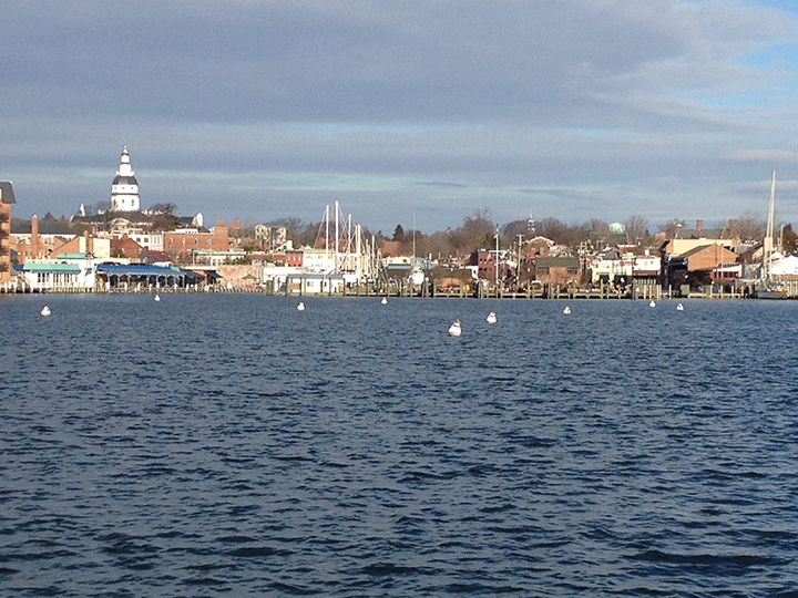
Annapolis’ location as an historic colonial port and a major governmental and institutional center reflects a city of 33,000 residents that, today, is the state capital, the commercial center for Anne Arundel County, the home of St. John’s College and the US Naval Academy (USNA), and the regional boating center for the Chesapeake Bay. The location enables access to major cities and Washington, DC, yet the community retains its small-town ambience. The combination of a historic city with an active recreational waterfront ensures that Annapolis remains as a city with a high quality of life.4
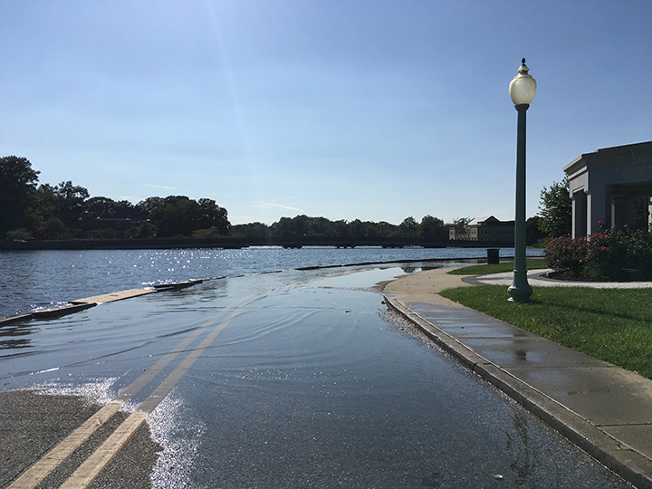
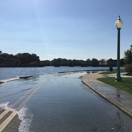
From 1950–2011, Anne Arundel County experienced 60 flood events, two hurricanes, three tropical storms, 19 tornadoes, 41 thunderstorm and high-wind events, 41 lightning events, and 56 hailstorms. Many of these events caused property damage, injuries, and deaths. Between 1957–1963, Annapolis saw 3.8 days on average per year of nuisance flooding, a term defined as occasional minor coastal flooding experienced during high tide. Fifty years later, between 2007–2013, Annapolis had on average 39.3 days of nuisance flooding per year, or a tenfold increase.5 In a report by the Union of Concerned Scientists, by 2065 Annapolis is forecast to experience daily tidal flooding, almost another tenfold increase.
Geographically, the downtown flood risk area rises rapidly from the shoreline toward the hills occupied by the State House and St. Anne’s Church, leaving a narrow coastal plain. The waterfront incorporates the original harbor as shown on early plans of the city, an area modified over decades through fill and bulkhead construction. Many people living in Annapolis have vivid memories of this area from Hurricane Isabel in 2003 when floodwaters rose to 6.4 feet. At that level, 60 out of 140 properties with verified elevations flood. If an Isabel‐equivalent storm surge happens in 2050, 84% of the historic properties will be flooded.
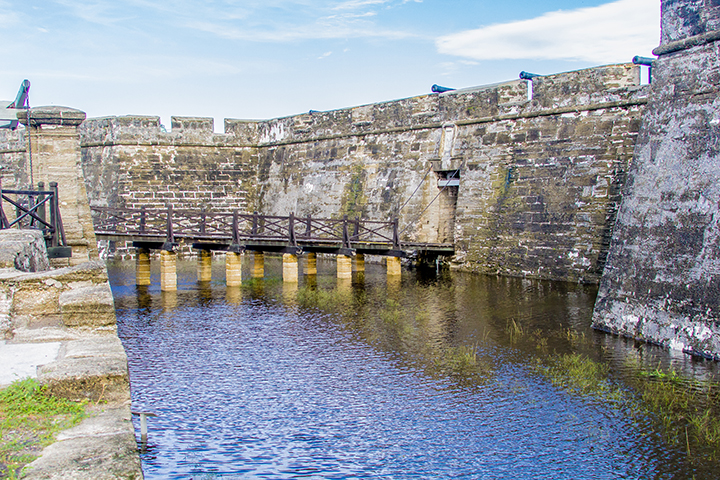
Spanish St. Augustine, founded in 1565, is the oldest continuous European and African-American city in the United States, with archaeological resources dating back 14,000 years. St. Augustine is the first city designed on Spanish King Phillip II’s 1573 Laws of the Indies.6 The plaza was the center of the city geographically, symbolically, and socially and continues in that role. The nation’s only 17th-century fortification, the Castillo de San Marcos, anchors the north boundary. The nation’s oldest Catholic mission and the site of the first muster of citizen-soldiers troops add significance to the city.7
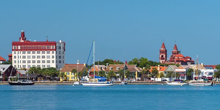
Downtown, Flagler College is one of the city’s major cultural assets and largest employers. In 2017, the campus that includes 19 historic buildings earned a ranking as one of the most beautiful campuses in the world. The centerpiece of the college is the former Hotel Ponce de Leon, an elaborate Gilded Age hotel designed by New York architects Carrère & Hastings, with the world’s largest collection of Tiffany stained glass windows, electricity by Thomas Edison, and murals reproduced a decade later in the Library of Congress.8
As noted in the New York Times, “St. Augustine has become an idyllic city of colleges, museums and tourism.” The small coastal city of 15,000 residents is one of the nation’s most popular cities in which to retire, as well.9
Among St. Augustine’s memorable hurricanes were three the city experienced in the summer of 1886 while the Hotel Ponce de Leon was under construction. In 1944, during World War II, when the Coast Guard Reserve occupied the Hotel, sailors rescued stranded residents and shared the hotel with evacuees. Three weeks after Flagler College opened in 1968, Hurricane Gladys passed through the city, dropped five inches of rain in a short time, and assisted in motivating the withdrawal of 15% of the new student body.10
St. Augustine experiences brushes with hurricanes on an average of every 2.2 years. Most recently, two in 11 months, Matthew on October 7, 2016, and Irma on Patriot Day, September 11, 2017, drew international attention. City streets flooded, and hundreds of residents experienced displacement. In the year since Hurricane Irma, the city’s historic African-American community of Lincolnville has witnessed the demolition of more than 100 buildings. Storm surges, increased tidal flooding, and an estimated one foot of sea-level rise by 2050 jeopardize the future of the city’s urban core and surrounding historic districts.11
Establishing community value through civic engagement
Building a more resilient and sustainable city requires a variety of activities, one of which is establishing community value for historic properties and cultural resources. A ranking process is created that responds to many variables, i.e., historic designation status, level of significance, degree of integrity, public sentiment, and economic importance. Planners and preservationists must engage the community to understand the “public sentiment” for historic places as a critical component of hazard mitigation planning. Guidance for developing this framework is provided through the Federal Emergency Management Agency (FEMA) publication Integrating Historic Property and Cultural Resource Considerations into Hazard Mitigation Planning: State and Local Mitigation Planning How-To Guide.
In preparing a Cultural Resource Hazard Mitigation Plan (CRHMP), FEMA considers the special status of designated landmarks and defines how they “may complicate recovery efforts.” More importantly, FEMA addresses how these historic places serve as assets and their protection creates multiple benefits for “citizens who love their communities and want to protect their historic and cultural assets.”12
Developing a Hazard Mitigation Plan (HMP) is a way for communities “to identify risks and vulnerabilities associated with natural disasters, and develop long-term strategies for protecting people and property from future hazard events.” This is a four-step process: (1) organize the planning process and resources, (2) assess risks, (3) develop a mitigation strategy, and (4) adopt and implement the plan. Each governmental jurisdiction must have an HMP to qualify for FEMA post-disaster assistance.13
This FEMA process provides specific guidance for incorporating historic properties into hazard mitigation planning, determining properties at risk, prioritizing those most important to the community, evaluating hazard mitigation actions through benefit-cost analysis and other decision-making tools, and developing and implementing a CRHMP. Retaining elements of cultural value “reinforce connections with neighbors and the larger community.”14
Annapolis: Weather It Together
Under the brand Weather It Together, Annapolis stakeholder team members developed a plan to further resilience and sustainability for the downtown. The following statement drove the plan’s goals, objectives, and actions: “By implementing Weather It Together: A Cultural Resource Hazard Mitigation Plan for the City of Annapolis, the historic Chesapeake Bay community will survive and thrive by building resilience, embracing sustainable development and adapting to hazards and natural disasters that threaten the Capital City’s cultural and natural heritage.”15
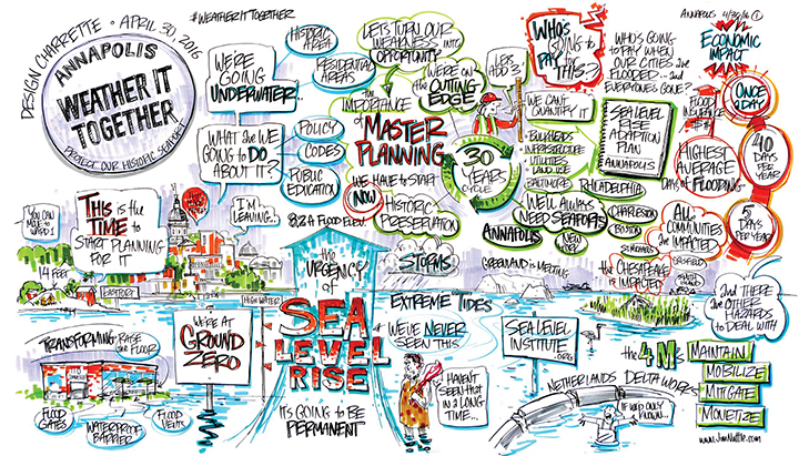
Beginning in November 2013, Weather It Together hosted nearly monthly core team stakeholder meetings, a town hall (attended by 250 people), a community forum (125 people), special lectures, and large public events such as the John Englander lecture and book signing at St. John’s College, funded through an Urban Land Institute–Baltimore Chapter grant, which drew a crowd of more than 600. Members of the planning team spoke at local and state government meetings, civic and nonprofit events, and state and national conferences.
In working with stakeholder agencies, residents, business owners, property owners, and the greater community, the Weather It Together initiative focused on those downtown historic places that mattered most to the larger community. The Annapolis plan envisions protection of the natural heritage of the Chesapeake Bay, prioritizes preservation of historic properties with significant community value, demonstrates the importance of partnerships with public agencies and private stakeholders to reduce the costs and impacts associated with flood protection and flooding hazards, and promotes both short-term and long-term strategies for flood protection.
In November 2017, the effort culminated in the second annual Keeping History Above Water conference, co-hosted by the city of Annapolis and the Newport Restoration Foundation (NRF), with sponsorship from the Urban Land Institute, National League of Cities, and other key Weather It Together stakeholders. This conference drew 280 attendees from 24 states and 3 countries to share case studies and best practices in the adaptation of historic coastal cities.
To further this international dialogue on sea-level rise, communities were invited to host the next Keeping History Above Water convening. Building on the successes from Newport and Annapolis, St. Augustine was selected to host Keeping History Above Water in 2019.
St. Augustine: Heritage at risk
St. Augustine’s founding took place in the midst of a hurricane on September 8, 1565. That event was the first of many disasters and influenced the development of the city over the next five centuries. In 2014, the year before St. Augustine commemorated its 450th anniversary, the Union of Concerned Scientists published National Landmarks at Risk: How Rising Seas, Floods, and Wildfires are Threatening the United States’ Most Cherished Historic Sites. The cover image is a photograph of St. Augustine’s Castillo de San Marcos. The report noted:
Few cities in the United States boast as many historic distinctions as St. Augustine, FL, but its illustrious past and coastal location come at a price. The low-lying city is prone to flooding, storm surges, and erosion. And its aging infrastructure takes a beating even in light rainstorms, with nuisance flooding regularly closing streets in the historic districts.16
Today, St. Augustine is making strategic decisions as part of a comprehensive approach to maintain its irreplaceable historic resources, retain its unique character, and sustain its quality of life. The city of St. Augustine, in partnership with FEMA through a mitigation assistance grant, completed an award-winning $7 million infrastructure project in 2013. The 1830s coquina stone seawall that forms the eastern boundary of the historic downtown was preserved and reinforced within a 21st-century concrete framework.17
In 2016, the city participated in a Community Resiliency Initiative Pilot Project through the Florida Department of Economic Opportunity (DEO) with funding provided through the National Ocean and Atmospheric Administration (NOAA). The project evaluated how increases in coastal flooding could affect vulnerability and determined approaches that could be “integrated into existing local planning strategies” to improve resilience. Nuisance flooding is anticipated to be the city’s greatest challenge in the next two decades.18
Flagler College took a lead in public engagement programs to address sea-level rise locally. During the 2015–2016 academic year, the college launched Heritage at Risk, co-sponsored with a dozen local, state, and national partners. The free, public program series brought to the community international speakers in climate science, public policy, planning, law, marine science, and archaeology. The program series and an international conference sponsored with the Smithsonian Environmental Research Center drew more than 3,000 people.
Concurrently, the regional office of the Florida Public Archeology Network (FPAN) hosted at Flagler College furthered the statewide focus through a new initiative, Tidally United. A major component of the program, “Heritage Monitoring Scouts” or “HMS Florida,” trains volunteers in each Florida county to monitor cultural resources. Now, two years later, the program has joined with international partners to foster a global project.
In 2016–2017, Flagler College enlisted two dozen local, state, and national partners to implement a statewide public engagement workshop program. After beginning in St. Augustine, the series traveled to Sarasota, Pensacola, and Tallahassee. The November–May timeframe paralleled the annual winter resident and visitor season, when Florida’s population increases exponentially. The workshops emphasized the critical link between the area’s heritage and its economic base, addressing resiliency through geographic, cultural, socioeconomic, and political lenses. Hurricane Matthew’s arrival in October 2016 increased timeliness of and public participation in these workshops.
Sponsorship from the National Trust for Historic Preservation and from the National Park Service’s South Florida and Caribbean CESU (Cooperative Ecosystem Studies Unit) brought a focus to properties on public lands in Florida. These included the NPS-administered Castillo de San Marcos (1672–1695) and Fort Matanzas (1740) national monuments (both designated in 1924) at St. Augustine.19
From May 5–8, 2019, Flagler College, with more than a dozen organizations, including principal partners the University of Florida, the city of St. Augustine, and the Newport Restoration Foundation, hosted the international Keeping History Above Water conference in St. Augustine. Experts in urban planning, economic development, finance, communication, national security, technology, historic preservation, cultural heritage, and climate science participated.
In preparation for the conference, and with assistance from the National Trust for Historic Preservation, Flagler College hosted a workshop for the St. Augustine community. The program employed a public engagement strategy to foster decisions about resource integrity, adaptation strategies, and future actions to assist in hazard mitigation planning for cultural resources. Particularly in light of changes to FEMA regulations and requirements released in the past several months, timing is of the essence to address cultural resources.20
Conclusion
Annapolis and St. Augustine are making strategic decisions in building resiliency. Working with key community stakeholders, they are leading efforts to engage smaller historic communities in planning for a future of rising seas. Each city’s efforts are focused on a 30-year timeframe for adoption of significant policy changes and implementation of direct action steps. Now, historic preservationists from both cities are working together to share best practices and lessons learned in resilience planning at conferences, workshops, and community-based trainings.
Lisa M. Craig, The Craig Group
Leslee F. Keys, Flagler College
Corresponding author:
Lisa M. Craig
The Craig Group
400 E. Kettleman Ln., Ste. 206
Lodi, CA 95240 USA
lcraiggroup@gmail.com
Endnotes
1. Jane Wilson McWilliams, Annapolis: City on the Severn (Baltimore: Johns Hopkins University Press, 2011), 19.
2. Maryland National Register Properties, Colonial Annapolis Historic District, Inventory No: AA137. Lisa Craig, “Resilience in Annapolis—Creating a Cultural Resource Hazard Mitigation Plan,” The Alliance Review (National Alliance of Preservation Commissions, Summer 2018), 5, https://napcommissions.org/wp…/The-Alliance-Review-Summer-2018-Craig.pdf. Accessed September 3, 2018.
3. City of Annapolis Ward One Sector Plan, January 1993, 17.
4. Ibid.
5. William V. Sweet and John J. Marra, “2015 State of U.S. ‘Nuisance’ Tidal Flooding,” in
State of the Climate, National Oceanic and Atmospheric Administration’s National Centers for Environmental Information. https://www.ncdc.noaa.gov/monitoring-content/sotc/national/2016/may/sweet-marra-nuisance-flooding-2015. Accessed September 15, 2018.
6. J. Michael Francis, St. Augustine, America’s First City: A Story of Unbroken History and Enduring Spirit (Eckbolsheim, France: Editions du Signe, International Publishing House, 2015), 1.
7. Florida National Guard, “Florida celebrates 445th Anniversary of ‘First Muster,’” Guard News, September 17, 2010. www.nationalguard.mil/News/…/florida-celebrates-445th-anniversary-of-first-muster/. Accessed September 10, 2018.
8. Leslee F. Keys, Hotel Ponce de Leon: The Rise, Fall, and Rebirth of Flagler’s Gilded Age Palace (Gainesville: University of Florida Press, 2015), 1–3.
9. Jess Bidgood, “After Irma, a Grim Sense of Déjà Vu in St. Augustine,” New York Times, September 13, 2017. https://www.nytimes.com/2017/09/13/us/st-augustine-irma-flood.html. Accessed September 15, 2018.
10. The Hurricane,” St. Augustine Record, October 19, 1944, 1; “U. S. Coast Guardsmen and SPARS Devote Facilities,” St. Augustine Record, October 22, 1944, 4; “Hurricane Gladys, October 14–20, 1968.” http://www.wpc.ncep.noaa.gov/tropical/rain/gladys1968.html. Accessed December 18, 2016.
11. Stacy R. Stewart, “National Hurricane Center Tropical Hurricane Report: Hurricane Matthew, (AL142016), April 7, 2017.” https://www.nhc.noaa.gov/data/tcr/AL142016_Matthew.pdf. Accessed September 15, 2018. John P. Cangialosi, Andrew S. Latto, and Robbie Berg, “National Hurricane Center Tropical Hurricane Report: Hurricane Irma, (AL112017), June 30, 2018.” https://www.nhc.noaa.gov/data/tcr/AL112017_Irma.pdf. Accessed September 15, 2018.
12. Federal Emergency Management Agency, Integrating Historic Property and Cultural Resource Considerations into Hazard Mitigation Planning: State and Local Mitigation Planning How-To Guide, FEMA 386-6/May 2005. https://www.fema.gov/pdf/fima/386-6_Book.pdf, iii. Accessed September 12, 2018.
13. Ibid.
14. Ibid.
15. City of Annapolis, Weather It Together: A Cultural Resource Hazard Mitigation Plan for the City of Annapolis, April 2018. https://www.annapolis.gov/DocumentCenter/View/10064/Consolidated-CRHMP-Report-April-2018, xvi. Accessed September 13, 2018.
16. Union of Concerned Scientists, National Landmarks at Risk: How Rising Seas, Floods, and Wildfires are Threatening the United States’ Most Cherished Historic Sites, 2014. https://www.ucsusa.org/…/national-landmarks-at-risk-from-climate-change.html, 40. Accessed September 12, 2018.
17. “Avenida Menendez Seawall Project.” http://staugustineseawall.com/. Accessed September 13, 2018.
18. Pilot Study: Florida Adaptation Planning.” https://www.fsbpa.com/17AnnualConfPresentations/Chris%20Zambito.pdf. Accessed September 13, 2018.
“Coastal Vulnerability Assessment: City of St. Augustine.” http://www.citystaug.com/document_center/Publicworks/Resiliency/CoastalVulnerabilityAssessment06.24.16.pdf, 5, 8. Accessed September 13, 2018.
19. In Pensacola, this emphasis addressed Fort Pickens (1834–1847) on Santa Rosa Island, part of the NPS-administered Gulf Islands National Seashore (1971), and Eglin Air Force Base (1933–present), now used for military and private equipment testing. The property includes the Eglin Field Historic District (National Register of Historic Places, 1998). Near Sarasota, Anna Maria Island faces retreat.
20. “Grant Programs Directorate Environmental Planning and Historic Preservation Policy Guidance FEMA Policy #108-023-1.” https://www.fema.gov/…/GPD_EHP_Policy_Final_Amendment_GPD_final_508.pdf. Accessed September 15, 2018.