Christopher E. Johnson, Vida Germano
Abstract
Cultural landscapes are complex systems of natural and cultural resources that are affected by changes in climatic and non-climatic factors. The National Park Service, Pacific West Region, has developed a vulnerability assessment (VA) model for identifying, evaluating, and responding to the effects of climate change to cultural landscapes by utilizing peer-reviewed data and local knowledge to inform management strategies that can reduce the vulnerability of cultural landscapes to deterioration and loss. Key to developing site-specific adaption plans is a VA based on analysis of the significance, exposure, and sensitivity of landscape characteristics and features, and identification of the management capacity to reduce the sensitivity of the cultural landscape to change. The resulting assessment compares the level of projected vulnerability of the landscape as a whole and of each characteristic or feature under evaluation, and the identification of methods for minimizing the sensitivity of the cultural landscape to climate change. This paper provides an overview of the VA model through case studies from the state of Washington, the territory of Guam, and Tinian, commonwealth of the Northern Marianas Islands.
Introduction
Climate change poses complex problems for the preservation of natural and cultural resources. Environmental variables associated with a changing climate, such as sea-level rise, changes in temperature and precipitation, and changes in ocean chemistry, put natural systems at risk, contribute to degradation and loss of cultural landscapes, and threaten traditional cultural practices. Resource vulnerability is also a factor of nonclimatic variables such as development on adjoining lands, pollution, and public use impacts, which can compound adverse effects resulting from exposure to climate variables. Site management capacities ranging from funding and staffing availability, availability of research, and access to traditional knowledge can further affect the susceptibility of natural and cultural resources to damage, deterioration, or loss.
This paper outlines an approach to utilizing local knowledge to help evaluate the multiple, interrelated variables that contribute to resource vulnerability in the context of climate change. The essay is based on an ongoing National Park Service (NPS) project to develop a vulnerability assessment (VA) model for cultural landscapes in the Pacific West Region (PWR). While primarily intended for cultural landscapes in the US national park system, the model incorporates research and decisionmaking strategies that are adaptable to a range of resource types and management systems.
The PWR VA model developed through a series of case studies of cultural landscapes in the region. The project team found that while synthesizing published climate data and cultural resource documentation created a generalized picture of observed and projected risk factors, a more complete accounting of vulnerability relied on accessing the observations and experience of site staff and others with firsthand knowledge of local patterns of ecological change, existing impacts, and the strengths and weaknesses of the local site management system. To capture this information, the team adopted a research process involving review of published landscape and climate data, a questionnaire for site staff and other consulting parties, a guided site visit, and a structured workshop. This approach helped fill gaps in the published data by creating a clearer picture of local natural processes and observed changes. It also provided information about existing management capacities for addressing impacts, and ensured that assessments and treatment recommendations were informed by traditional cultural knowledge whenever possible.
The PWR approach builds on existing VA models for cultural resources in two respects. First, it offers a systematic approach to incorporating local knowledge of natural and cultural systems and observed patterns of ecological change into the assessment. Second, it integrates findings from climate science with analysis of other site-specific contributors to vulnerability, including management capacity to respond. In both respects, the model is consistent with a shift toward more integrated, policy-oriented assessments that evaluate interactions between climatic and nonclimatic factors to determine vulnerability.1 The goal is to enable site managers to select adaptation alternatives that are informed by the best available science and scholarship; promote preservation of cultural resources in accordance with applicable laws and policies; and reflect site-specific priorities, knowledge, and capacities.
Background and summary of the PWR cultural landscape VA model
Work on the PWR VA model began in 2015 in response to a need for a structured approach to addressing the effects of climate change on cultural landscapes in the region. Initial research conducted by University of Oregon (UO) Cultural Landscape Research Group resulted in a three-phase “decision tree” for evaluating and responding to the effects of climate change on cultural landscapes.2 The process involved compiling site-specific climate and cultural landscape data into a VA (Phase 1: Research); selecting management alternatives based on the VA (Phase 2: Planning); and implementing, monitoring, and adjusting management actions over the long term (Phase 3: Stewardship). In 2017, UO worked with PWR staff to compile climate projections for the region and completed condition assessments for six sites selected as case studies.3
While UO’s research provided an important first step, NPS reviewers determined that additional work was necessary to refine the methodology and ensure consistency in application. PWR cultural resources staff resumed work on the framework in 2017, focusing on revisions to the VA model. Building on research conducted by UO, the team defined four components of a VA:
- A statement of significance of the cultural landscape including a list of contributing landscape characteristics and features with notes on integrity. The statement of significance typically derives from National Register of Historic Places nominations or comparable documentation.
- Evaluation of the observed and projected exposure of contributing landscape characteristics and features to changing climate variables. This involves documenting changes in climate variables that are currently observable in the cultural landscape and those that are projected to be present in the future.
- Evaluation of the observed and projected sensitivity of contributing landscape characteristics and features to exposure to changing climate variables. “Sensitivity” refers to the susceptibility of the cultural landscape to adverse effects. This step involves analysis of existing condition and impacts. It also includes documentation of observed and projected effects resulting from the interaction of climatic and nonclimatic risk factors, the latter of which may include deferred maintenance, pollution, development on adjoining lands, visitor use impacts, etc.
- Evaluation of management capacity to reduce sensitivity. This involves preliminary consideration of available treatments ranging from preservation maintenance and minor rehabilitation or stabilization, to major rehabilitation or relocation of contributing landscape characteristics and features. It also considers the ability of the existing management system to identify, select, and implement appropriate treatment alternatives. The management capacity evaluation correlates with an evaluation of adaptive capacity, which the Intergovernmental Panel on Climate Change (IPCC) identifies as a core component of vulnerability. In the IPCC definition, adaptive capacity refers to “the ability of systems, institutions, humans, and other organisms to adjust to potential damage, to take advantage of opportunities, or to respond to consequences.”4 The PWR model also follows from the NPS Cultural Resources Climate Change Strategy, which notes that adaptation opportunities for cultural resources typically lie in “our use and management of them” rather than in their inherent capacity to adapt.5 “Adaptive capacity” in cultural resource management thus refers primarily to the capacity of the management system to reduce sensitivity.
Vulnerability, in summary, is a measure of the exposure and sensitivity of a significant cultural landscape to climate variables, taking into account management capacity to respond to observed and projected changes. An assessment that records the vulnerability of individual contributing features as well as the landscape as a whole offers an informed basis for identifying, prioritizing, and implementing management actions to address climate-related impacts. The assessment is also intended as a living document. The degree of vulnerability may change as new information becomes available, as the management system changes, or as adaptation measures are implemented.
Research process
The PWR assessment model adheres to a defined process involving close collaboration with site managers, staff, and other consulting parties.6 The steps include: synthesis of published landscape documentation and climate data, a questionnaire completed by site staff and other collaborators, a guided site visit, and an interdisciplinary workshop to discuss information gathered through the previous steps. The process brings together information from published sources with the observations of site staff and other knowledgeable parties regarding local patterns of environmental change, observed changes in the condition of resources, existing site management priorities and programs, and anticipated challenges and opportunities for addressing climate-related impacts. The workshop is the critical step during which the four components are discussed in detail. The results are compiled in a datasheet indicating the vulnerability of individual contributing landscape characteristics and features. A narrative assessment of the vulnerability of the landscape as a whole is also prepared. The combination of high sensitivity to exposure to climate variables and low management capacity to reduce sensitivity indicates a high level of vulnerability.
Local collaboration ensures that both climatic and nonclimatic contributors to resource vulnerability are factored into the assessment. It also helps address uncertainties due to lack of local climate data or lack of information about the performance of historic materials exposed to climate variables. In some cases, local contacts can provide information that is missing from the available literature, including through photographic documentation of changing conditions or recollections of past natural disasters. Capturing local knowledge of past events and trends results in tentative estimates of how natural and cultural systems will respond to projected changes in exposure. While not always conclusive, these estimates provide a more complete picture of sensitivity than is possible through review of published data alone. They also move adaptation planning in directions that address site-specific data gaps and are more responsive to local knowledge and capacities.
Local knowledge also informs the management capacity evaluation. The process identifies areas where additional research or documentation is needed to complete an evaluation of sensitivity or select appropriate adaptation alternatives. It also provides for a clearer understanding of staff hiring and training needs, and identifies site-specific characteristics such as land ownership patterns and existing partnerships that enhance or limit managers’ ability to reduce resource exposure and sensitivity.
It is important to note that the management capacity component is meant as a preliminary evaluation. Similar to a cultural landscape report or comparable treatment document, the VA functions as a bridge between the research and planning phases of the cultural resource management process. Additional evaluation of management alternatives still occurs during a subsequent planning phase as defined in NPS Management Policies, the NPS Cultural Resources Climate Change Strategy, and the UO climate change decision tree.7 The VA provides direction for this larger process. It ensures that planning is based on the fullest possible understanding of a resource’s significance and susceptibility to damage, deterioration, or loss. It also ensures that local knowledge of site-specific impacts and the strengths and weaknesses of the existing management system informs discussion of treatment alternatives from the start of the planning phase.
Case study I: Buckner Homestead Historic District, North Cascades National Park, Washington
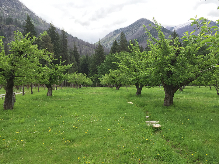
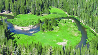
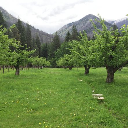
The Buckner Homestead Historic District was selected as an early case study for applying the VA process. The district is significant for its association with early settlement and agricultural development in the North Cascades region of Washington state from 1889–1955. Buckner Homestead occupies 160 acres and is located on a horseshoe bend of the Stehekin River in Lake Chelan National Recreation Area, a unit of North Cascades National Park. Its significance is conveyed primarily through a historic apple orchard with a ditch irrigation system fed from nearby Rainbow Creek. Other features include a cluster of historic buildings, an adjacent pasture, and a road connecting the features of property and extending through a mixed Ponderosa pine and Douglas fir forest.
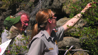
The cultural landscape was found to be sensitive to variables related to temperature and precipitation change, including lower snowpack, more intense periods of precipitation, wildfire, flooding, higher temperatures, and drought. The apple orchard was identified as an area of concern due to effects on tree vigor and the risk of catastrophic losses from river flooding and wildfire. The workshop provided valuable information on historic climate exposure and resource sensitivity that was not available in the published literature. Park natural resources staff helped identify impacts to the cultural landscape resulting from changes in the larger ecosystem of the Stehekin Valley. The discussion also brought attention to existing park programs to address current impacts, including some associated with climate change. These included programs to control invasive species and reduce fire fuel loads. The park’s part-time orchardist also shared knowledge of specialized techniques for pruning, propagation, grafting, and maintenance of the irrigation system. These methods improve tree resilience to a range of impacts related to snow loading, elk feeding on bark during the winter, drought, visitor traffic, and excessive summer heat.
It became clear from the evaluation that these programs were already reducing the sensitivity of the orchard to risks associated with temperature and precipitation changes. Adaptation alternatives were identified that would build on existing site management capacities. This included enabling the orchardist to continue to adapt pruning and grafting techniques, propagation and mowing schedules, and maintenance of the irrigation system to changing environmental conditions. Management capacity was found to be lower in other areas due to data gaps and staffing and funding constraints. The lack of available research on the heat and drought tolerances of rare historic apple species in the orchard, for example, was identified as limiting the park’s ability to complete a full sensitivity evaluation. Completing this research will aid the park in selecting additional adaptation measures.
Case study II: War in the Pacific National Historical Park, Guam
Following the initial case studies, PWR staff continued to refine the research process to better incorporate local knowledge and account for management capacity. This included adding a questionnaire to provide additional structure to the site visit and workshop.
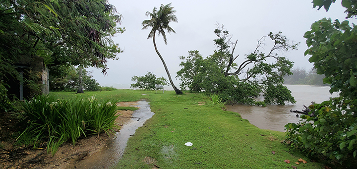
The revised VA model was applied in July 2018 at War in the Pacific National Historical Park (WAPA) on Guam. The park consists of seven noncontiguous units associated with nationally significant events related to America’s involvement in World War II. It is additionally significant for its potential to yield archaeological information related to the American invasion of Guam beginning on July 21, 1944. The units include the US invasion landing beaches at Asan and Agat villages, Japanese defensive fortifications, and upland areas where key events of the battle of Guam occurred.
Sensitivities include deterioration and damage to coastal fortifications from saltwater inundation and exposure to wave action associated with sea-level rise; declining coral reef health due to a variety of factors, including bleaching associated with rising ocean temperatures; shoreline erosion; impacts to savanna vegetation resulting from greater risk of fire and drought; and erosion of earthen fortifications during typhoons and heavy rains. Workshop participants provided additional information on the extent and frequency of past floods, fires, and typhoons to supplement gaps in the published climate data for Guam.
Discussions during the site visit and workshop also drew attention to interconnected impacts on the broader “ridge-to-reef” cultural landscape. For example, loss of vegetation in upland units due to savanna fires (resulting from a combination of drought conditions and intentionally set hunting fires) increases erosion during heavy precipitation events, contributing to damage to earthworks and sedimentation of the coral reefs downstream. These impacts are exacerbated by off-road vehicle use in upland areas.
The second half of the workshop involved discussion of potential actions to reduce sensitivity of specific characteristics and features of the ridge-to-reef cultural landscape. The discussions highlighted the value of interdisciplinary collaboration in identifying adaptation alternatives. Potential treatment options include shoreline stabilization through restoration of mangroves and other native plants at river mouths to protect sensitive Japanese fortifications, native plant revegetation in upland areas with monitoring of the effects on soil stability, partnering with the Guam Youth Conservation Corps to conduct supervised invasive vegetation removal at Japanese fortifications, and public outreach to reduce the impacts of savanna fires and off-road vehicle use to the ridge-to-reef cultural landscape.
The discussion also brought attention to factors limiting the park’s ability to select and implement treatment alternatives. Incomplete baseline documentation, including lack of an up-to-date inventory of archaeological resources, was identified as an immediate issue. Lack of documentation of ethnographic resources also limits the park’s ability to identify significant cultural sites and evaluate their exposure and sensitivity. At the time of the assessment, the park did not have determinations of National Register of Historic Places eligibility for commemorative monuments at Asan beach which are exposed to flooding during storms. Up-to-date documentation of historic, archaeological, and ethnographic resources would allow for a more complete evaluation of the sensitivity of the cultural landscape, and would better prepare the park to identify and prioritize adaptation alternatives.
Physical separation of the seven park units poses additional challenge for landscape-scale planning. Issues related to private landownership and limited staff capacity for sustained community engagement hinder the park’s ability to prevent uses that exacerbate climate-related impacts. Park lands, especially the inland units, are also not clearly marked or consistently monitored for prohibited uses. Park outreach efforts have had some positive results despite these challenges. For example, a recent campaign to discourage hunting fires in upland areas by demonstrating the impacts of erosion on reef fish habitat may have contributed to fewer fires in recent years.
The workshop resulted in several recommendations for addressing management capacity limitations as well as more specific resource sensitivities. Completing baseline documentation was identified as a priority that would promote greater responsiveness, flexibility, and accountability in addressing projected and unexpected risk factors associated with climate change. Other recommendations focused on building capacity through interdepartmental planning, resource monitoring, collaboration with adjacent landowners, and partnerships to address sensitivities related to maintenance needs, gaps in climate data, and public use impacts.
Case study III: North Field National Historic Landmark, Tinian, Commonwealth of the Northern Mariana Islands
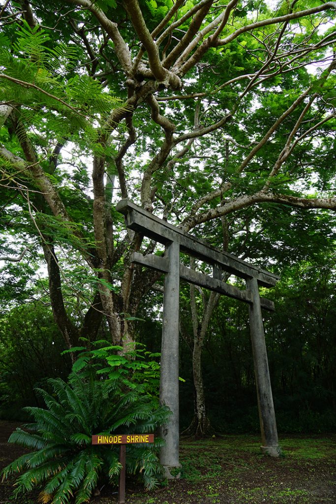
North Field National Historic Landmark (NHL) located on Tinian in the Commonwealth of the Northern Mariana Islands (CNMI) served as the location for an NPS-led workshop to introduce the PWR VA model to Pacific Island Historic Preservation Office (HPO) staff. Held in August 2018, the workshop provided an opportunity to apply the VA approach at a site outside the US national park system.
The North Field NHL is significant for its association with events of World War II, including the US invasion of Tinian, B-29 bombing raids of the Japanese home islands, and the deployment of the atomic bombs over Hiroshima and Nagasaki. The NHL and surrounding cultural landscape also contain resources associated with early Chamorro settlement, pre-war Japanese colonization and settlement, and ongoing Indigenous cultural practices. Contributing landscape characteristics and features include archaeological sites, airfield surfaces, roadways, battle-damaged Japanese buildings and defensive fortifications, invasion beaches, Shinto shrines, and naturalized remnant vegetation. Natural systems and features, including remnant native limestone forests, traditional fishing areas, coral reefs, and limestone cliffs, also contribute to the historic character.
Through classroom discussion and field work, participants recorded information about the significance of contributing cultural landscape characteristics and features, and evaluated their sensitivity to sea-level rise, ocean temperature and acidification, typhoons, and changes in temperature and precipitation. Historic roads and airfield surfaces were found to be sensitive to accelerated deterioration and vegetation overgrowth related to increasing temperatures and precipitation. The assessment relied heavily on the knowledge of Chamorro cultural practitioners and experts in Micronesian history who participated in the workshop. At Unai Dangkulo, a beach located south of the NHL, these individuals identified significant marine species that were sensitive to changes in ocean temperature and acidification, medicinal plants sensitive to changes in temperature and precipitation, as well as coastal freshwater springs and a unique petroglyph site susceptible to inundation from sea-level rise.
The evaluation also revealed potential management options for reducing sensitivity. These include: keeping vegetation away from highly sensitive historic buildings, roads, and runways to limit material degradation and erosion; repairing and treating historic airfield and road surfaces to improve resilience; removing large trees at risk of falling during typhoons and damaging historic resources; developing public education programs to reduce visitor impacts to archaeological and cultural sites; designating sensitive traditional fishing areas as marine protected areas to prevent overfishing; and collaborating with marine scientists to explore options for improving coral reef resilience to maintain culturally important marine species and protect beaches from erosion.
CNMI HPO’s existing management capacity to carry out these actions is low on Tinian due to limited staff, funding, and access to equipment. However, opportunities for collaboration with other CNMI government agencies, NPS, academic institutions, nonprofit organizations working on climate change adaptation in the Pacific Islands, and the US military, which leases the land for periodic military training, may be available to increase management capacity. More frequent regular maintenance of resources in poor condition, including the airfield surfaces and roads, can also substantially reduce sensitivity of the World War II cultural landscape.
Conclusion
The PWR VA model offers a structured approach to assessing not only direct impacts from exposure to climate variables but also how those variables interact with other nonclimatic factors to affect resource vulnerability. This requires incorporating analysis of published climate data and cultural resource documentation with relevant information on local natural systems, site condition, impacts, and management capacities gained from collaboration with site staff and other consulting parties. The VA is intended as an initial decision point in a larger process of developing and implementing an adaptation plan. It organizes the best available information on significance, exposure, sensitivity, and management capacity to inform selection of management options. It also identifies areas where additional research, partnerships, or other site management support may be needed to implement treatment alternatives.
To further improve the VA’s usefulness as a planning tool, the PWR cultural resources program is continuing to refine the approach based on lessons learned during the case studies. This includes development of a rubric for assigning vulnerability ratings of low, moderate, or high to contributing resources within a landscape, as well as for the landscape as a whole. The rubric is based on evaluation of each of the four VA components. A consistent rating system will aid in prioritization of management responses and promote greater accountability in management decisionmaking. It will also facilitate updates to VAs over time in response to unexpected changes or availability of new information.
Christopher E. Johnson, National Park Service
Vida Germano, National Park Service
Corresponding author:
Christopher E. Johnson
Preservation and Partnerships Program, Pacific West Region
National Park Service
909 First Ave., 5th Floor
Seattle, WA 98104
christopher_e_johnson@nps.gov
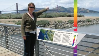
[Ed. note: This article originated as a presentation at the US/ICOMOS (US Committee of the International Council on Monuments and Sites) International Symposium “Forward Together: A Culture–Nature Journey Toward More Effective Conservation in a Changing World,” held in November 2018 at The Presidio, San Francisco, California, USA. The symposium explored the understanding that cultural and natural heritage are dynamic and inextricably linked in many landscapes and waterscapes, and that effective and long-lasting conservation of these places depends on better integration of the “entangled dimensions” of culture and nature. An earlier version of this article is included in the complete symposium proceedings, available at https://usicomos.org/past-symposia/.]
Endnotes
- Hans-Martin Füssel and Richard J.T. Klein, “Climate change VAs: An evolution of conceptual thinking,” Climatic Change 75 (2006): 301–329.
- Robert Z. Melnick, Noah P. Kerr, Veronica Malinay, and Olivia Burry-Trice, Climate Change and Cultural Landscapes: A Guide to Research, Planning, and Stewardship (Eugene: Cultural Landscape Research Group, University of Oregon, 2017).
- Robert Z. Melnick, Veronica Malinay, Noah P. Kerr, and Alison Lewis, Study of Climate Change Impacts on Cultural Landscapes in the Pacific West Region, National Park Service (Eugene: Cultural Landscape Research Group, University of Oregon, 2016).
- Intergovernmental Panel on Climate Change [IPCC], “Glossary,” in Climate Change 2014: Impacts, Adaptation, and Vulnerability, Part B: Regional Aspects, Contribution of Working Group II to the Fifth Assessment Report of the Intergovernmental Panel on Climate Change, V.R. Barros, C.B. Field, D.J. Dokken, M.D. Mastrandrea, K.J. Mach, T.E. Bilir, M. Chatterjee, K.L. Ebi, Y.O. Estrada, R.C. Genova, B. Girma, E.S. Kissel, A.N. Levy, S. MacCracken, P.R. Mastrandrea, and LL. White, eds. (New York: Cambridge University Press, 2012), 1758.
- Marcy Rockman, Marissa Morgan, Sonya Ziaja, George Hambrecht, and Alison Meadow, Cultural Resources Climate Change Strategy (Washington DC: Cultural Resources, Partnerships, and Science and Climate Change Response Program, National Park Service 2016), 32.
- The process is designed to be carried out by qualified cultural resources professionals with experience collecting, synthesizing, and analyzing climate data. This could include qualified NPS staff, contractors, or site managers as appropriate.
- National Park Service, Management Policies 2006 (US Department of the Interior, National Park Service, 2006), 60; Rockman et al., Cultural Resources Climate Change Strategy, 27.; Melnick et al., Climate Change and Cultural Landscapes, 9.