Abraham J. Miller-Rushing, Brian Henkel, Rebecca Cole-Will
Abstract
Changes in climate and associated changes in seasonality, invasive plants and insects, and visitation are stressing ecosystems and infrastructure in Acadia National Park. Over the past five years, park staff and partners have begun taking an interdisciplinary, partnership-based approach to assessing baseline conditions, identifying stresses, developing climate change scenarios, and restoring the ecological and cultural integrity and resilience of whole watersheds. The approach contrasts with past resource management in which managers frequently tackled problems with minimal coordination between disciplines (e.g., water, wildlife, cultural resources, and maintenance) and locations. The result has been a series of projects that have begun to measurably improve the health of one of the park’s most visited and iconic watersheds: the Cromwell Brook watershed, which includes Sieur de Monts (Acadia began in 1916 as Sieur de Monts National Monument) and the Great Meadow, and whose namesake waterway flows through the gateway town of Bar Harbor. Projects (inside and out of the park) have included rehabilitating a historic spring pool, replacing undersized culverts with open-bottom bridges, removing a poorly sited septic system, removing invasive plants, restoring native wetland, establishing monitoring to assess changes in watershed health, and working with the town and other stakeholders to plan future projects that would further improve the health of Great Meadow and downstream areas in Bar Harbor. The combination of planning; monitoring; restoring healthy, functioning ecological communities; and minimizing stresses from human infrastructure and visitation offer the best chance of maintaining Acadia National Park for the enjoyment of future generations.
Introduction
Rapid changes in climate and other socioecological conditions are forcing protected area managers to adjust their approaches. For decades we have known that the long-time goal of many protected areas to preserve past conditions or “vignettes of primitive America” (Leopold et al. 1963) is not possible (Halpin 1997). However, conservation theory and management practices are still catching up with how to maintain the health of natural and cultural resources in a rapidly changing environment.
Here we describe an initiative in Acadia National Park intended to help park staff and partners adjust our approach to match this new reality. The initiative, called Wild Acadia, began in 2013 as a result of ongoing discussions between the National Park Service (NPS) and the nonprofit Friends of Acadia. We recognized that the “stovepiped” and project-based structure of park resource management—in which different disciplines such as wildlife, vegetation, and water functioned more or less independently and focused on individual projects rather than more holistic and forward-looking goals—was not adequate in a rapidly changing environment. We also were reluctant to begin formal strategic planning processes, like those associated with NPS natural resource stewardship and science strategies that were starting to be implemented in other parks at the time. We wanted to pursue a more flexible planning process that we could experiment with before formalizing a long-term strategy. So we identified goals and target outcomes (Box 1) and began developing Wild Acadia as a flexible pilot to test and model approaches to managing resources in a changing climate.
Box 1. Goals and target outcomes for Wild Acadia initiative
Overarching goal
Restore and maintain Acadia National Park’s natural and cultural resources and maintain sustainable infrastructure in a manner that will preserve ecological and cultural integrity and promote resilience to changes in climate, air and water pollution, and invasive species, as well as other changes such as increases in visitation.
Specific goals over the next 5 years
- Significantly improve ecological integrity, connectivity, resilience, and sustainable infrastructure in the pilot watershed of Cromwell Brook.
- Improve connectivity, resilience, and sustainable infrastructure in the second priority watershed, Marshall Brook, and associated drainages to the Bass Harbor Marsh.
- Use modeling, research, and monitoring to assess the efficacy of short-term strategies, anticipate future changes and inform necessary adjustments to achieve long-term Wild Acadia goals.
- Communicate the Wild Acadia approach and progress to partners, the community, and other parks and protected areas.
Target outcomes over the next 20–30 years
- Park natural and cultural resources will change in ways that maintain their ecological and cultural integrity.
- Park management will evolve to a culture of comprehensive, adaptive management.
- Park staff, partners, residents, and the visiting public will be aware of changes taking place at Acadia and the park’s approach to managing those changes, and they will participate in stewardship of natural and cultural resources.
A snapshot of Acadia National Park and Friends of Acadia
Acadia National Park is located in Hancock County, Maine. The park began as Sieur de Monts National Monument in 1916, and now preserves approximately 50,000 acres of glacially sculpted landscapes on Mount Desert Island, the Schoodic Peninsula, Isle au Haut, and 16 smaller islands. Acadia lies in a transition zone between temperate deciduous and northern coniferous forest in the Gulf of Maine and features a mosaic of habitats, including sub-alpine vegetation on the mountains, open lakes in steep watersheds, and significant wetlands. Acadia boasts 33 miles of historic motor roads, 120 miles of hiking trails, and 45 miles of unique carriage roads; all three of these circulation systems are listed on the National Register of Historic Places. With nearly 3.7 million visits in 2018, Acadia was the seventh most-visited national park, but the smallest in land size of the top ten most-visited parks.
Friends of Acadia, founded in 1986, is an integral partner to the park on many activities. Among its signature programs are its endowments to fund work on Acadia’s hiking trails and carriage road, youth programs, transportation initiatives, and the Wild Acadia initiative. They provide conservation grants, mobilize volunteers, and advocate for the health of Acadia National Park. Through the Wild Acadia initiative, Friends of Acadia supports the monitoring of resources within watersheds, management of invasive plant species, and provides grants to partner organizations (e.g., Schoodic Institute, College of the Atlantic, Maine Natural History Observatory, and University of Maine) that implement science-based resource management activities.
Changes in climate and other conditions in Acadia National Park
Acadia National Park is experiencing stresses from climate change typical of the northeastern United States (Fernandez et al. 2015; Dupigny-Giroux et al. 2018). Temperatures have warmed on par with the global average. Annual precipitation and the intensity of storm events has increased. The growing season has lengthened substantially, contributing to ecological changes and increases in visitation (Fisichelli et al. 2015; Monahan et al. 2016). Sea levels have risen, and damage from storm surges and flooding has increased. Associated with changes in climate (although not solely caused by climate change), the park has experienced increases in non-native, invasive plants and insects, and vector-borne diseases. These changes are stressing park ecosystems, cultural resources, and infrastructure, and further change is expected to continue into the foreseeable future.
The park also has several historical features that impede the ability of species and ecosystem function to adapt to changing conditions. For example, many streams are obstructed by dams, undersized or perched culverts, and other barriers. Some park trails, roads, and other infrastructure were constructed in wetlands, floodplains, or in coastal areas; this infrastructure now floods more frequently and blocks the migration of wetlands and coastlines.
Initial planning
When beginning to implement the Wild Acadia initiative, we took a holistic, interdisciplinary, partnership-based approach. Friends of Acadia committed to raising funds (leveraging existing NPS funds) to support the development and implementation of the process. For planning and coordination, this funding allowed us to hire a full-time coordinator (one of us, B. Henkel), hire consultants as needed, and purchase software and technologies to help with planning (Box 2).
Box 2. The Wild Acadia approach: Our implementation of adaptive management based roughly on the Open Standards for the Practice of Conservation
Resources
- Institutional commitment and funding from NPS and nonprofit partner (Friends of Acadia)
- Project coordinator
- Funding for planning consultants and software tools
- Funding for implementation of projects, monitoring, data management, and assessment
- Strong partners to participate in planning, implementation, and progress assessments
Actions: Adaptive management cycle
- Use existing data, models, and expertise to identify conservation targets and threats, understand resource conditions, and prioritize strategies. Start the process with park staff, then refine and finalize at workshop(s) with key experts and partners.
- Identify priority watersheds to focus management actions. Park staff initially identified them, then worked with key partners, especially those with a stake in the watersheds, to assess and finalize the priority watersheds.
- Plan and implement priority strategies, including whether to resist, adapt to, or facilitate change. Identify, track, and communicate key milestones and indicators of progress and success; visual indicators are great when they are possible.
- Implement monitoring and research to assess changes in resource conditions (focusing on indicators). Synthesize and assess monitoring results every five years.
- Based on syntheses, identify successes and failures to meet objectives and identify new solutions or research projects that could point to new solutions.
- Communicate lessons learned to NPS staff, partners, and the public.
- When appropriate, revisit the beginning of the planning process—update models, identify the next priority watershed, plan and implement priority strategies, etc.
In 2015, we began planning in earnest. We worked with the organization Foundations of Success to use the Open Standards for the Practice of Conservation, which provide a shared terminology and approach for conservation planning (CMP 2013). Over several weeks we developed a conceptual model linking conservation targets (e.g., wetlands, forests, intertidal zones), threats to them, and drivers and interactions among those threats (Figure 1). We then held a two-day workshop with roughly 25 agency, academic, and nonprofit partners to refine our draft conceptual model and develop priority strategies for addressing the threats. Soon after developing the conceptual model and priority strategies, we held another two-day workshop with roughly 45 climate experts, NPS staff, and partners to develop climate change scenarios and assess their potential impacts on our conservation targets, management actions, and general operations (Star et al. 2015).
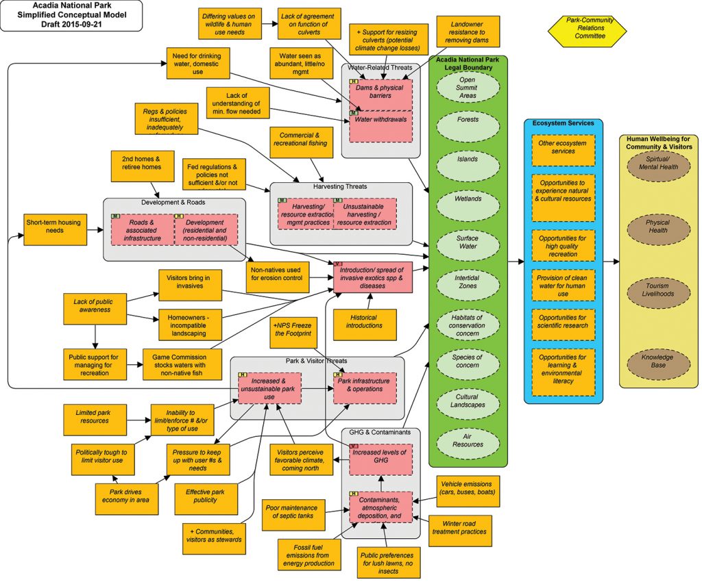
At the end of this planning, we had a conceptual model outlining the park’s conservation targets and threats to their health (Figure 1) and an assessment of how different climate scenarios might affect our management strategies (Star et al. 2015). These outputs gave us a solid basis to begin implementing management strategies on the ground. We refer to these planning products on a regular basis and continue to update our conceptual model and strategies.
Our first watershed
To focus our initial implementation and help us assess and communicate outcomes, we targeted one watershed. Using a watershed as our starting unit provided a contained ecological and physiographic area to focus our actions and monitoring. We chose to begin with the Cromwell Brook watershed, part of which occurs in Acadia National Park and part on private and public lands in Bar Harbor, the main gateway community for Acadia (Figure 2). This watershed is highly visited by locals and visitors and has a mix of management issues that benefit greatly from a holistic, interdisciplinary approach.
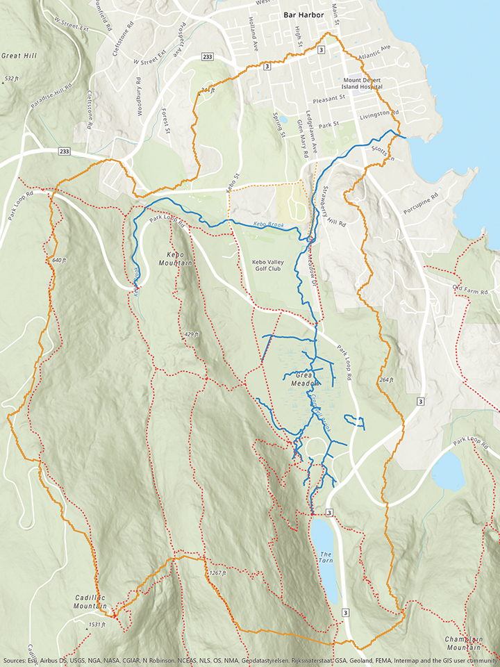
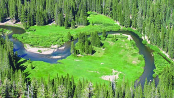
The high-elevation portion of the watershed is within the park and includes two low-elevation mountains (Dorr and Kebo). The mid-elevation portion of the watershed, still within the park boundaries, includes a shallow pond (the Tarn), a cultural landscape that served as the original entrance to the park (Sieur de Monts), a small botanical garden (Wild Gardens of Acadia), the second largest wetland in the park (Great Meadow), a stretch of the Park Loop Road that crosses the outlet of Great Meadow, and a number of historic trails. The low-elevation portion of the watershed is within the Town of Bar Harbor and contains an abandoned dump, an active transfer station, a golf course, the town’s wastewater treatment facility, a recently abandoned public works facility that held sand and salt for winter road treatment, a public ballfield complex, three road-stream crossings that obstruct stream connectivity, and private residences.
Much of the trail system accessing Dorr and Kebo Mountains was developed prior to the formation of the park. The Tarn also pre-dates the park; it was created through the construction of a low dam at the outlet of a meadow, which flooded the meadow and created a shallow lake that is now filling with sediment and returning to the conditions of a meadow. Downstream of the Tarn, the Great Meadow was also significantly altered prior to the park’s formation; it was used for growing cranberries, as a source for soil, and as a fish hatchery, and was crossed with historic roads, some of which are now trails. It was also heavily invaded with non-native plants, such as purple loosestrife (Lythrum salicaria) and glossy buckthorn (Frangula alnus). Alterations to Great Meadow continued after the formation of the park, including the straightening of Cromwell Brook through the wetland, ditching of the meadow, and peat removal.
Surveys suggest that the diversity of fish species in Cromwell Brook is among the greatest of any stream in Acadia National Park (Havird et al. 2011). The clam flats at the outlet of the brook are closed because of contamination issues that the brook may be contributing to. Flooding in Great Meadow and the Sieur de Monts area has increased in recent years because of increases in the incidence of extreme rainfalls, especially in the winter, exacerbated by alterations in the hydrology caused by historic uses of Great Meadow. As climate conditions continue to change (e.g., heavy precipitation and changing forest composition), the health of Great Meadow will be important for flood control and for maintaining water quality in the lower reaches of Cromwell Brook. Without active management, changing conditions will likely increase the vulnerability of Great Meadow to reinvasion by non-native plant species and inability to bounce back from future disturbance.
Actions, results, and outcomes
Wild Acadia projects have begun to measurably improve the health of the Cromwell Brook watershed. The park and partners have implemented a number of management actions aimed at restoring the natural wetland hydrology, stream connectivity, and biodiversity; rehabilitating cultural landscapes; and improving infrastructure. We believe these actions are critical to enhancing the ecological and cultural integrity of the watershed and enhancing its ability to bounce back after future disturbances and adapt to changes in climate conditions (Box 1). Below we describe some of the projects we have implemented to date.
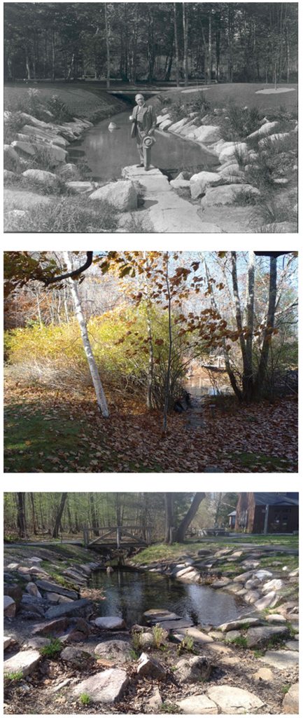
Rehabilitating a cultural landscape. We began addressing degraded landscape conditions in the Cromwell Brook watershed in 2013, with a project to rehabilitate the historic spring pool at Sieur de Monts (Figure 3). The pool is an original feature of park founder George B. Dorr’s vision for the park. Built about 1909, Dorr designed a cultural landscape, featuring the spring pool at its center. The pool featured a bubbling spring surrounded by crafted cut stone and plantings. Over time, the spring pool had degraded, water quality was poor, and it was obscured and surrounded by invasive plants. The park’s exotic plant management team removed invasives, the highly skilled trails crew completely reset the stones, and a landscape of native plants was created.
Removing invasive plants from Great Meadow and the surrounding landscape. In 1990, non-native, invasive plants—particularly purple loosestrife and glossy buckthorn—were among the most common species in the Great Meadow and low-lying forests immediately around the wetland. These invasives displaced native plant species and impaired the health of the wetland. Aggressive removal of the invasive species over several years has reduced their abundance in the wetland and surrounding forests to the point that we are now primarily managing new invasions—a remarkable success. The removal required extensive effort, including mechanical cutting and pulling, targeted application of herbicides, and the help of volunteers. We are now encouraging private landowners in the watershed and other nearby areas to remove invasive plants on their properties, which will improve the health of the larger landscape and reduce seed sources for new invasions.
Restoring stream connectivity and improving road crossings. Many of the culverts in Acadia and surrounding areas were originally installed in the period between the 1930s and 1950s. Nearly all of them are too small to accommodate the large rainfalls that have become more common in recent years; areas upstream of these culverts frequently flood during large storms (Figure 4). Many culverts have also caused erosion on their downstream ends and have become perched, preventing passage by fish and other wildlife. At one location on Cromwell Brook within the park, we have replaced a culvert with an open-bottom bridge that spans the full bank-width of the stream. This design accommodates high stream flows and passage by wildlife. We are now planning a similar replacement of an undersized culvert at the outlet of Great Meadow. In addition to these projects in the park, we worked with the town of Bar Harbor to improve riparian habitat and reduce sedimentation when it replaced a bridge over a lower portion of Cromwell Brook. We are currently working with the town on plans to replace two more sets of culverts at places where the stream crosses roads. One option we are considering is to move the stream entirely to its historical channel, which would remove the need for the stream to cross the road. (Early in the 20th century the road was built on a stretch of Cromwell Brook and the stream was diverted to cross the road in two locations.) Another option would be to simply improve the design of the culverts to facilitate passage by fish and other wildlife.
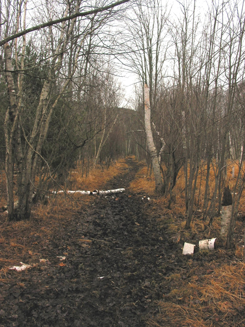
Improving wetland health. Activities prior to the creation of Acadia National Park and early in the park’s history substantially harmed the health of Great Meadow. The wetland was heavily altered, crossed with trails, and a portion developed through the construction of a parking lot, restrooms, and a septic system. Water quality monitoring showed that the septic system—which should not have been sited in a wetland—was leaking and causing algae blooms in the Sieur de Monts spring pool. We removed the septic system, tied the restrooms into the town sewage system, and restored the area formerly occupied by the septic system to native wetland. In a separate location in Great Meadow, we rehabilitated a trail (Jesup Path) that obstructed water flow and was muddy much of the year; we replaced the old trail with a boardwalk that restored natural hydrology, maintained the historic path of the trail, and was designed wide enough to increase accessibility for strollers and wheelchairs (Figure 5). We are now starting to plan the restoration of the vegetation and hydrology other portions of Great Meadow. These early stages of planning have included workshops with park staff and scientists, as well as public presentations to discuss the goals of the project and desired future conditions for the wetland.
x 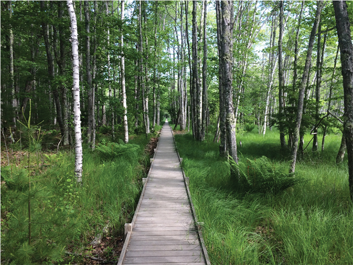
Monitoring to assess changes in watershed health. To assess changes in watershed health—both improvements caused by management actions and harm caused by disturbances—we have established targeted monitoring within the watershed. The backbone of this monitoring is NPS inventory and monitoring of vital signs already happening throughout Acadia. As a part of Wild Acadia, we have expanded monitoring to locations in the Cromwell Brook watershed critical to assessing responses to management actions, including areas outside of the park boundary. Monitoring of stream macroinvertebrates, water quality, stream discharge, wetland water levels, wetland plant communities, forest health, and the abundance of invasive species is being done collaboratively by NPS staff, US Geological Survey scientists, College of the Atlantic and University of Maine faculty and students, and Friends of Acadia interns. We are also working with the Schoodic Institute to organize targeted citizen science monitoring of biodiversity and phenology in the area of Great Meadow. We plan to analyze data from these monitoring efforts every five years, starting in 2021, to assess changes in watershed health and responses to management actions.
Next steps
As we continue management projects in the Cromwell Brook watershed, we have begun planning and some early management activities in our second watershed—Marshall Brook, located on the western side of Mount Desert Island. Like the Cromwell Brook watershed, the Marshall Brook watershed includes park land and lands in neighboring towns (Southwest Harbor and Bass Harbor). The watershed includes extensive wetlands, the park’s largest salt marsh (Bass Harbor Marsh), and a suite of management issues similar to those that occur in the Cromwell Brook watershed.
We have identified candidate sites for management actions, done some initial site assessments, and started one management project: a culvert replacement on private land in cooperation with the landowner and the Maine Department of Environmental Protection. We also have public presentations planned to engage local communities in the project.
Conclusions
The importance of partnership. The public–private partnership between NPS and Friends of Acadia has been critical to the success of the project. The partnership facilitated funding, hiring, implementation of projects beyond park boundaries, and collaboration with other partners. We were able to leverage a combination of NPS base funds, project funds, and private funding from grants and an endowment at Friends of Acadia. Friends of Acadia also facilitated the hiring of key consultants in a timely manner and helped NPS work with partners on projects outside of park boundaries, which would have been difficult for the agency to do on its own.
Improving and leveraging deferred maintenance projects. As NPS plans and implements deferred maintenance projects in the coming years, the Wild Acadia approach offers an opportunity to assess current infrastructure in the context of a holistic set of conservation targets and management priorities, and to apply an adaptive management approach to planning, implementing, assessing, and revising infrastructure projects. For example, as a result of Wild Acadia work, we have prioritized the replacement of the undersized culvert at the outlet of the Great Meadow and have brought in a lot of science and planning to inform the design of the new open-bottom structure. The new bridge will handle larger water flows (based on climate projections), improve the hydrology of Great Meadow, and improve passage for fish and other wildlife. Moreover, we plan to implement other management actions, such as plugging ditches in Great Meadow, to enhance the benefits to the wetland hydrology. The climate scenarios, hydrology expertise (provided in part by B. Henkel, the Wild Acadia coordinator), and complementary management projects that have improved the design of the new structure and that will improve its effectiveness would not have been possible without the Wild Acadia initiative.
Developing a culture of resource management appropriate for a changing environment. A major goal of the Wild Acadia initiative is to shift the culture of resource management to one that naturally takes a comprehensive, adaptive management approach, rather than focusing on individual projects in isolation. We believe that the initiative is already helping to develop this type of culture among park staff and key science and conservation partners. Collaboration across disciplines within resource management has increased, as have collaborations across the resource management, facilities, and interpretation divisions. Moreover, we are able to more clearly communicate our goals, management framework, and priority actions to science and conservation partners, which greatly facilitates collaborative research, monitoring, communication, and volunteer opportunities.
Unexpectedly, the initiative has also allowed us to more effectively engage new audiences in resource management and climate change adaptation. For example, the board of Friends of Acadia is now much more engaged in climate change adaptation than they have been in the past; we can use concrete examples from Wild Acadia to explain the impacts of climate change and how we are adapting to them. The same is true for public audiences in the towns adjacent to the park. We have a concrete, well-defined framework in place to describe the impacts of climate change and how our management actions and monitoring fit together to maintain the health of natural and cultural resources as conditions change. Thus, our culture of resource management and climate change adaptation is expanding beyond the boundaries of even the staffs of the park and our partners to include surrounding communities.
We are extremely pleased with the first five years of Wild Acadia and look forward to continuing the initiative in future years.
Abraham J. Miller-Rushing, National Park Service, Acadia National Park
Brian Henkel, Friends of Acadia and Maine Natural History Observatory
Rebecca Cole-Will, National Park Service, Acadia National Park
Corresponding author:
Abraham J. Miller-Rushing
Acadia National Park
PO Box 177
Bar Harbor, ME 04609 USA
abe_miller-rushing@nps.gov
References
CMP [Conservation Measures Partnership]. 2013. Open Standards for the Practice of Conservation, Version 3.0. http://cmp-openstandards.org/.
Dupigny-Giroux, L.A., E.L. Mecray, M.D. Lemcke-Stampone, G.A. Hodgkins, E.E. Lentz, K.E. Mills, E.D. Lane, R. Miller, D.Y. Hollinger, W.D. Solecki, G.A. Wellenius, P.E. Sheffield, A.B. MacDonald, and C. Caldwell. 2018. Northeast. In Impacts, Risks, and Adaptation in the United States: Fourth National Climate Assessment, Volume II, D.R. Reidmiller, C.W. Avery, D.R. Easterling, K.E. Kunkel, K.L.M. Lewis, T.K. Maycock, and B.C. Stewart, eds. Washington, DC: US Global Change Research Program, 669–742. https://doi.org/10.7930/NCA4.2018.CH18.
Fernandez, I.J., C.V. Schmitt, S.D. Birkel, E. Stancioff, A.J. Pershing, J.T. Kelley, J.A. Runge, G.L. Jacobson, and P.A. Mayewski. 2015. Maine’s Climate Future: 2015 Update. Orono, ME: University of Maine.
Fisichelli, N.A., G.W. Schuurman, W.B. Monahan, and P.S. Ziesler. 2015. Protected area tourism in a changing climate: Will visitation at US national parks warm up or overheat? PLOS ONE 10(6): e0128226.
Halpin, P.N. 1997. Global change and natural-area protection: Management responses and research directions. Ecological Applications 7(3): 828–843.
Havird, J.C., J.K. Parker, and B. Connery. 2011. Fishes of the streams of Acadia National Park, Maine. Northeastern Naturalist 18(2): 217–228. https://doi.org/10.1656/045.018.0208.
Leopold, A.S., S.A. Cain, C.M. Cottam, I.A. Gabrielson, and T.L. Kimball. 1963. Wildlife Management in the National Parks. Washington, DC: National Park Service.
Monahan, W.B., A. Rosemartin, K.L. Gerst, N.A. Fisichelli, T. Ault, M.D. Schwartz, J.E. Gross, and J.F. Weltzin. 2016. Climate change is advancing spring onset across the US national park system. Ecosphere 7(10):e01465.
Star, J., N. Fisichelli, A.M. Bryan, A. Babson, R. Cole-Will, and A. Miller-Rushing. 2015. Acadia National Park climate change scenario planning: Workshop summary. Winter Harbor, ME: Schoodic Institute at Acadia National Park.


